0.5 mi
245 ft
Difficult
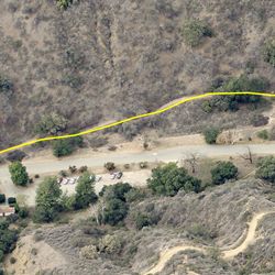
The trail climbs up from Malibu Creek through a low saddle between two ridgelines. Connect with Crags Road and Mott Road to create a nice loop. If continuing on to High Road via Crags
Road, note this section may impassable when wet. Chaparral Trail is generally open and exposed to direct sun. Closer to Crags Road, the trail turns north and provides views to the creek valley below.
Chaparral Trail can be accessed from the main entrance at Malibu Creek State Park via Crags Road. From the 101, exit at Las Virgenes Rd in Calabasas and head south for 3.4 miles. The park entrance is just past Mulholland Hwy on the right. From the PCH, turn east onto Malibu Canyon Rd. Continue onto the Las Virgenes Rd. Park entrance on left after 1 mile.
ALLOWED USES:
- Hiking
- Horseback Riding